🏔️ Geotectonic Cornerstone: Batholiths as Plutonic Engines of Subduction Arcs
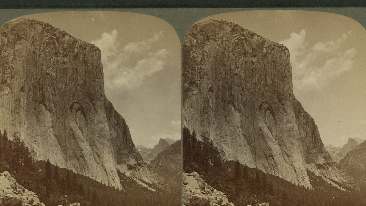
A batholith is not a singular, gargantuan magma chamber that froze in a single cataclysmic pulse; rather, it represents a composite composite collage of hundreds of individual plutonic pulses, dikes, and sills incrementally accreted over tens of millions of years in the roots of volcanic arcs. The Sierra Nevada Batholith, immortalized in Yosemite’s towering granite monoliths of El Capitan and Half Dome, stands as the premier global laboratory for pluton emplacement dynamics, magma stoping, and post-orogenic glacial exhumation.
1. The Continental Arc Setting: Mesozoic Subduction along the Western Cordillera
During the Mesozoic Era—spanning from the late Triassic (~210 Ma) through the late Cretaceous (~85 Ma)—the western margin of North America functioned as an Andean-type active convergent margin. The dense, oceanic Farallon plate subducted eastward beneath the buoyant North American continental lithosphere along an extensive trench situated hundreds of kilometers offshore.
As the hydrous Farallon oceanic slab descended into the high-temperature, high-pressure regimes of the upper mantle, slab dehydration liberated supercritical aqueous fluids rich in silica, alkalis, and dissolved salts into the overlying mantle wedge (peridotite). Flux melting of the asthenospheric mantle generated primary basaltic magmas. These primitive, high-temperature mantelic melts ascended buoyantly into the lower continental crust (at depths of 30 to 45 km), ponding in deep crustal hot zones termed MASH (Melting, Assimilation, Storage, and Homogenization) zones.
Within these deep crustal incubation zones, mantle basalts underplated and partially melted the ancient pre-existing continental crust, generating intermediate to felsic, hybrid calc-alkaline magmas (diorite, granodiorite, and granite). Over a span of roughly 130 million years, pulse after pulse of these buoyant silicic magmas rose into the upper crust (5 to 12 km depth), coalescing to construct the colossal Sierra Nevada Batholith—a continuous belt of plutonic rock stretching over 650 kilometers along the spine of eastern California.
2. Pluton Emplacement Mechanics: The Great ‘Space Problem’ of Plutonism
For over a century, structural geologists and petrologists grappled with the fundamental ‘room problem’ or space problem of plutonism: how do millions of cubic kilometers of molten silicic rock displace rigid, pre-existing solid crustal host rock to carve out immense batholithic bodies? Detailed field mapping in Yosemite and modern analog modeling identify three primary mechanical processes that operate synchronously and sequentially to accommodate magma ascent:
- 1. Magmatic Stoping: Formulated by Reginald Aldworth Daly in the early 20th century. Ascending magma fractures the brittle roof and wall rocks through thermal shock, hydraulic wedging, and fluid overpressure. Dislodged rectangular blocks of host rock—termed xenoliths or stoped blocks—sink into the lower density magma bath, allowing the magma to advance upward into the evacuated space. Yosemite’s contact zones, such as the May Lake roof pendant, exhibit spectacular networks of granitic dikes enveloping angular, partially assimilated metasedimentary blocks.
- 2. Ductile Wall-Rock Displacement and Ballooning: In the hotter, deeper ductile crust, ascending plutons expand outward like inflating balloons. Magmatic hydraulic pressure drives forceful shouldering aside, ductile folding, and vertical ductile squeezing of the surrounding metamorphic country rock, generating steep foliation envelopes and rim synclines surrounding pluton borders.
- 3. Floor Depression and Roof Uplift (Laccolithic Models): Modern geochronology demonstrates that many plutons are emplaced as horizontal tabular sheets (sills) fed by vertical feeder dikes. Accumulation of successive sheets forces the floor of the magma chamber downward into the ductile lower crust while uplifting the volcanic roof in broad regional doming.
| Plutonic Unit | Rock Classification | Crystallization Age (Ma) | Dominant Minerals | Signature Yosemite Landmark |
|---|---|---|---|---|
| El Capitan Granite | Biotite-hornblende granite to granodiorite | 103 ± 1 Ma (Early Cretaceous) | Quartz, K-feldspar, Plagioclase, Biotite | El Capitan (South Face), Ribbon Fall |
| Taft Granite | Leucocratic biotite granite | 102 ± 2 Ma (Early Cretaceous) | Quartz, Microcline, Albite (scarce mafics) | Upper cliffs of El Capitan, Taft Point |
| Sentinel Granodiorite | Hornblende-biotite granodiorite | 95 ± 1 Ma (Late Cretaceous) | Plagioclase, Quartz, Hornblende, Biotite | Sentinel Rock, Glacier Point apron |
| Half Dome Granodiorite | Porphyritic hornblende-biotite granodiorite | 89 ± 0.5 Ma (Tuolumne Intrusive Suite) | Plagioclase, Quartz, Sphene, K-feldspar megacrysts | Half Dome, Clouds Rest, Tenaya Lake |
| Cathedral Peak Granodiorite | Porphyritic granodiorite with giant microcline | 88 ± 0.4 Ma (Tuolumne Intrusive Suite) | Giant microcline phenocrysts (up to 8 cm) | Cathedral Peak, Tuolumne Meadows |
| Johnson Granite Porphyry | Fine-grained aplite to granite porphyry | 85 ± 1 Ma (Final Suite Core) | Quartz, Orthoclase, trace muscovite | Core of Tuolumne Meadows Intrusive Complex |
3. The Tuolumne Intrusive Suite: Incremental Magmatic Assembly and Zonation
Within Yosemite National Park, the premier textbook example of composite pluton assembly is the celebrated Tuolumne Intrusive Suite (TIS). Covering over 1,100 square kilometers, the suite was previously envisioned as a single concentric magma chamber that cooled slowly from the outer rim inward. However, modern high-precision Uranium-Lead (U-Pb) zircon geochronology conducted by secondary ion mass spectrometry (SIMS) and CA-ID-TIMS has revealed a far more dynamic history:
The Tuolumne Intrusive Suite was incrementally constructed over an extended duration of at least 8 to 10 million years, between 93 Ma and 85 Ma, through four distinct, nested concentric magmatic pulses:
1. Marginal Kuna Crest Granodiorite (93–91 Ma): The outermost, earliest, and most mafic shell, rich in hornblende, biotite, and calcium-rich plagioclase, formed by mingling between mafic dikes and crustal melts.
2. Half Dome Granodiorite (91–88 Ma): An immense intermediate unit characterized by large, lustrous wedge-shaped crystals of titanite (sphene) and well-developed magmatic foliation defined by aligned hornblende laths. Half Dome itself is carved from this extraordinarily durable, homogeneous pluton.
3. Cathedral Peak Granodiorite (88–86 Ma): The spectacular central unit, famous worldwide for hosting giant, euhedral megacrysts of potassium feldspar (microcline) measuring up to 5 to 8 centimeters in length. Detailed chemical profiling indicates that these giant crystals grew over hundreds of thousands of years within a mushy magmatic crystal slurry subjected to periodic thermal pulses and magma recharge.
4. Johnson Granite Porphyry (85 Ma): The tiny, highly evolved felsic core of the suite, representing the final residual, volatile-depleted granitic liquid that squeezed into the center of the solidifying Cathedral Peak magma mush.
🔬 Petrogenetic Milestone: The Magma Mush Paradigm
Modern plutonic petrology has abandoned the simplistic concept of massive subterranean ‘liquid magma oceans’. High-precision thermal modeling and seismic tomographic imaging prove that plutonic systems spend over 90 percent of their lifespan as high-crystallinity (>50–70% solid) ‘magma mush’ beds, which can only erupt or mobilize when rejuvenated by hot, mantle-derived basaltic recharge pulses.
4. Tectonic Exhumation and Orogenic Collapse: Unroofing the Batholith
Because granitic batholiths crystallize at depths between 5 and 15 kilometers beneath the surface, their presence as towering mountain monoliths today requires colossal tectonic uplift and unroofing. In the Sierra Nevada, this exhumation was driven by a sequence of dramatic Cenozoic plate tectonic reorganizations:
During the Laramide Orogeny (~75 to 45 Ma), the subducting Farallon slab flattened against the base of the North American lithosphere, shutting off arc volcanism and initiating widespread crustal uplift. Throughout the early and middle Cenozoic, regional subaerial erosion stripped away several kilometers of the overlying volcanic superstructure—the ancient Mesozoic volcanoes and calderas that once vented Yosemite’s magmas to the sky—leaving behind only tiny, isolated metamorphic roof pendants (such as Mount Dana and Mount Gibbs).
Beginning roughly 15 to 20 million years ago, the initiation of the San Andreas transform fault and the tectonic extension of the Basin and Range province pulled the crust apart east of the Sierra Nevada. Catastrophic normal faulting along the Sierra Nevada Frontal Fault Zone tilted the entire Sierra crustal block westward like a giant rigid tectonic trapdoor. This massive tectonic tilt elevated the eastern crest of the range to elevations exceeding 4,000 meters, dramatically accelerating river incision by the ancestral Merced and Tuolumne rivers.
5. Geomorphic Sculpting: Exfoliation Jointing and Glacial Carving of Yosemite Valley
The final aesthetic transformation of Yosemite’s granitic monoliths into vertical sheer cliffs, towering spires, and rounded domes was governed by two synergistic geological mechanisms: sheet jointing (exfoliation) and Pleistocene glacial erosion.
1. Unloading and Exfoliation Domes: Granite is an isotropic crystalline rock lacking sedimentary bedding or tectonic foliation planes. When kilometers of overlying rock are removed by erosion, the immense vertical confining lithostatic pressure is released. Relieved of compressive stress, the granite expands radially outward toward the free surface. This stress release generates concentric curved fracture sets parallel to the topography, termed sheet joints or exfoliation joints.
As water enters these curved joints, freeze-thaw frost wedging peels away massive concentric rock slabs like the layers of an onion. The resulting curved, smooth landforms are world-famous exfoliation domes, epitomized by Half Dome, North Dome, and Sentinel Dome. The vertical 3,000-foot sheer monolith of El Capitan owes its survival to its extraordinary density and absence of primary joint sets, resisting both exfoliation and glacial quarrying.
2. Glacial Carving and U-Shaped Trough Genesis: During the Pleistocene Ice Ages (spanning the Tioga, Tahoe, and Sherwin glaciations between 2.5 million and 12,000 years ago), colossal alpine glaciers up to 1,000 meters thick filled Yosemite Valley. While pre-glacial rivers had carved a steep V-shaped canyon, the glaciers dramatically widened, deepened, and straightened the valley into a classic flat-floored, vertical-walled U-shaped glacial trough.
Glacial plucking quarried jointed granites along the valley walls, while subglacial abrasive silt polished the granite bedrock into gleaming glacial pavement. Tributary river valleys, lacking the erosive power of the main ice trunk, were left stranded hundreds of meters above the valley floor as classic hanging valleys, creating Yosemite’s iconic waterfalls: Yosemite Falls, Bridalveil Fall, and Nevada Fall.
6. Modern Rockfall Geohazards and Active Geomorphology
The geological evolution of Yosemite did not cease with the retreat of Pleistocene glaciers; rather, Yosemite Valley remains one of the world’s most dynamic and hazardous rockfall environments. The sheer, over-steepened granite cliffs left behind by retreating ice are inherently unstable and undergo continuous gravitational readjustment.
High-resolution terrestrial LiDAR scanning and seismic monitoring conducted by the United States Geological Survey (USGS) and the National Park Service record an average of 50 to 70 major rockfalls annually in Yosemite Valley. Trigger mechanisms include winter freeze-thaw cycling, thermal stress fatigue during hot summer afternoons (where solar heating causes outward thermal expansion of exfoliation flakes), heavy storm precipitation, and regional earthquakes along the Owens Valley fault system. Catastrophic historical rockfalls, such as the 1996 Happy Isles rockfall and the 2017 El Capitan rockfall, unleashed hundreds of thousands of tons of granite traveling at speeds exceeding 250 km/h, generating hurricane-force air blasts that flattened mature pine forests and reshaping the talus slopes of the valley floor.
🌍 Geological Legacy of Plutonism
From mantle flux melting beneath Mesozoic ocean trenches to the crystallization of giant microcline crystals in sluggish magma mushes, and from Basin-and-Range tectonic tilting to glacial gouging and active rockfall dynamics, Yosemite stands as a complete, living chronicle of deep-Earth plutonism, continental accretion, and geomorphic evolution.
7. Geochemical Fingerprinting and Nd-Sr Isotope Systematics
To decipher the exact proportions of juvenile mantle melt versus ancient continental crust assimilated during the petrogenesis of the Sierra Nevada Batholith, isotope geochemists utilize radiogenic Neodymium (Nd) and Strontium (Sr) isotope systematics. Because the mantle possesses high Sm/Nd and low Rb/Sr relative to continental crust, ancient crust evolves toward highly radiogenic ⁸⁷Sr/⁸⁶Sr (>0.710) and unradiogenic εNd (values of -5 to -15), whereas depleted mantle retains low ⁸⁷Sr/⁸⁶Sr (~0.703) and positive εNd (+6 to +10).
In Yosemite, plutons exhibit an extraordinary geographic isotopic gradient: the western foothills plutons display primitive, mantle-dominated isotopic signatures (⁸⁷Sr/⁸⁶Sr < 0.7045, positive εNd), indicating growth in juvenile island arc crust. In contrast, moving eastward across Yosemite toward the Sierra crest (El Capitan, Cathedral Peak), initial ⁸⁷Sr/⁸⁶Sr rises systematically above 0.7065 and εNd drops to negative values (-2 to -8). This boundary—termed the Sr 0.706 isopleth—delineates the western edge of the ancient Proterozoic North American cratonic continental basement buried beneath the Mesozoic magmatic arc, demonstrating that eastern Sierra plutons assimilated up to 40 to 60 percent pre-existing continental crust.
🪨 Isotope Petrology Landmark
The Sr 0.706 isopleth running through Yosemite marks the fundamental rifted continental boundary of ancient Laurentia formed during the Neoproterozoic breakup of Rodinia over 750 million years ago.
8. Paleoseismology of the Sierra Nevada Fault Scarp
The physical uplift of the Sierra Nevada batholith is accommodated along the colossal Sierra Nevada Fault Zone (SNFZ), a high-angle normal fault escarpment that bounds the eastern flank of the mountain range for over 600 kilometers. Paleoseismic trenching across Holocene alluvium and glacial moraines reveals that the SNFZ ruptures in infrequent but catastrophic earthquakes of moment magnitude (M_w) 7.5 to 8.0, with single-event vertical fault offsets of 3 to 6 meters.
Cosmogenic beryllium-10 (¹⁰Be) and chlorine-36 (³⁶Cl) exposure dating of polished granite fault scarps along the eastern Sierra shows that average long-term vertical fault slip rates range between 0.3 and 1.5 millimeters per year. This persistent tectonic unroofing and normal faulting maintains the extreme vertical relief of Mount Whitney (4,421 meters), creating one of the steepest topographic escarpments on the North American continent and ensuring that deep-seated plutonic rocks continue their vertical ascent into the upper crust.
🪨 Geotectonic Synthesis
The ongoing interplay between deep magmatic crystallization, regional crustal extension, and rapid glacial exhumation demonstrates that mountain batholiths are dynamic geotectonic engines actively shaped by both endogenic mantle forces and exogenic atmospheric processes.